
nakedeyeview.com.my 2008


pagenumber
Milford Track – A Luxurious Tramp Marred By A Traumatic Fall
(4th to 8th March 2011)
Pg 1
A . General
Milford Track is one of more than half a dozen tramping trails in Fiordland National Park, a World Heritage Site located in the south west of New Zealand’s South Island. It is known as the most famous tramping route in New Zealand with stunning scenery amidst mountains, waterfalls and lakes in temperate rainforests. It is also the wildest, wettest and most isolated part of New Zealand.
The trail is 54km long starting at the head of Lake Te Anau and terminating at Sandfly Point at Milford Sound. The trail follows the Clinton River to its source, crosses the Mckinnon Pass at 1,073m and continues down the Arthur Valley to Milford Sound. It traverses through rainforests, wetlands and an alpine pass. It is quite physically challenging as one has to negotiate rough terrains, high winds and rain.
 |
The trail can only be walked in one direction, from Glade Wharf to Sandfly Point. Walkers must complete the track in four days. The walking season is from late October to late April with a maximum of 40 independent walkers and 50 guided walkers to start the trail each day. Walkers can tramp the track independently or as part of a more expensive guided walk with Ultimate Hikes, the guided walk company which holds the only approved concession from the Department of Conservation (DoC) for overnight guided walks. Camping is prohibited on the trail.
Independent walkers must stay each night in lodges owned and operated by DoC. These lodges have basic facilities such as bunk areas, restrooms and cooking facilities. However the walkers have to carry their own equipment and food.
Guided walkers stay in lodges owned and operated by Ultimate Hikes. These lodges have facilities such as hot showers, beds, lounges, electric lights, drying rooms, hot meals and drinks including beers and wines. Guided walkers only have to carry clothing, toiletries, bed sheets and packed lunch while on the trail.
B. Organising The Tramp
This is our second attempt to tramp the Milford Track; the first was in early September 2008 when we were touring New Zealand with our spouses by cars. The men were prepared to tramp the Milford Track as independent walkers. When we arrived in Te Anau, we went to the office of DoC to enquire about the Track. But we were informed that the Track was quite inhospitable as certain sections were still blanketed in thick snow and avalanches were a frequent occurrence. As an alternative, we were informed that it would be safe to do the Kepler Track and stay for a night at Luxmore Hut. And that was the Track we did then.
In December 2010 we decided to make another attempt to tramp the Milford Track; but this time we wanted to do it as guided walkers as our experience in tramping the Kepler Track as independent walkers had taught us that to do it with heavy backpacks (more than 10kg) all the way would be tough and we would not enjoy the tramp.
I contacted Ultimate Hikes and the track by five walkers was confirmed starting on 4th March and returning on 8th March. The base for this expedition would be in Queenstown where the office of Ultimate Hikes is located. Queenstown is a convenient location for us to undertake this expedition as I have a serviced apartment located close to the town. To accommodate all the five walkers, I would have to book an adjoining studio unit.
The five walkers are: Kenny, KC, GK, Larry and me.
The Walkers
Each of us had a separate itinerary before and after the tramp as we had only to be in Queenstown on or before 3rd March.
My itinerary is as follows:
25 – 28 Feb --- in Auckland (staying in Chiefley Suites)
28 Feb – 3 March --- in Queenstown (Units 315 & 313 Aurum Apartment)
4 – 8 March --- Milford Track
8 – 10 March … in Queenstown (Units 315 & 313 Aurum Apartment)
10 – 14 March … in Auckland (staying in Celestion Apartment)
C. The Track
In summary the daily track can be summarized as follows:
Day 1 (4th March): Queenstown/Te Anau to Glade House;
Day 2 (5th March): Glade House to Pompolona Lodge;
Day 3 (6th March): Pompolona Lodge to Quintin Lodge;
Day 4 (7th March): Quintin Lodge to Sandfly Point and to Milford Sound and
Day 5 (8th March): Milford Sound to Queenstown.
Day 1 (4th March): Queenstown/Te Anua to Glade House
The adventure began at Ultimate Hikes’ office in Queenstown at 9.30am where twenty five walkers boarded a coach to Te Anau, arriving in time for a light lunch. After lunch we were driven to Te Anau Downs boat harbour, where a launch took us up to the spectacular northern end of Lake Te Anau. From the wharf it was a short walk (1.6km) to the historic Glade House, our first lodge.
 |
 |
Arriving at Glade Wharf |
The Glade House |
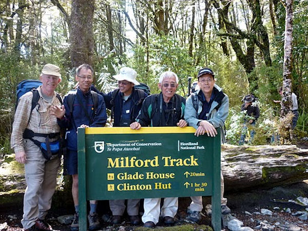
After checking into our bunk room with six bunk beds, we had a group photograph taken in front of the lodge. Three lady-guides, Claudine, Jess and Masako would be accompanying us all the way from start to finish. After the group photograph was taken a group of us were taken by one of the guides for a one-hour short nature walk to explore the surrounding area, our first taste of Milford Track.
 |
Group Photo taken in front of Glade House
After a hot shower, we had a three-course meal in the lounge. After dinner, we assembled for a briefing giving by one of the guides on our next day’s programme. Also we were to select our choice for the next day’s dinner.
The lights in all the bunk rooms would be switched off at 10pm and so we would retire to our comfortable bunk-bed to get some rest after the briefing. Attending the briefing and selecting the next day’s dinner was the routine we had to do for the next three days while on our track.
Day 2 (5th March): Glade House to Pompolona Lodge – 16km
Before our breakfast at 7.30am, we had to pack our lunch for the day. I packed two sandwiches with cheese, egg, salad, and ham. Again, this was the routine we had to do for the next two days.
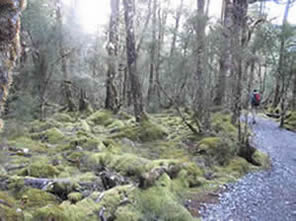
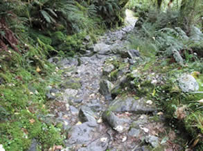
We left Glade House at 8.00am. We first crossed the emerald green Clinton River by a suspension cable bridge. Through lush beech forest we then made our way up the Clinton Valley to the Hirere Falls. Along the way we made detours to an area known as the wetland walk and 'the big tree'. The trail was generally flat and wide.
 |
 |
 |
 |
After lunch at the nearby Hirere Falls shelter, we went through beech forest which got more luxuriant the further we went and the valley walls climbed steeper and higher. We soon came to the Hidden Lake where a few walkers (including GK) went for a quick dip in the icy water.
 |
 |
 |
GK taking a dip in icy water!
 |
 |
|
 |
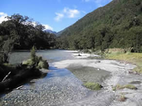
From here the track went onto the Prairie, an open meadow where one could capture the true nature of the ice carved Clinton Canyon. Shortly after, the trail started to ascend and reached a shelter called “Bus Stop”, a rain/flood shelter. From there it was a short climb to Pompolona Lodge, where we stopped for the second night on the Milford Track.
Day 3 (6th March): Pompolona Lodge to Quintin Lodge - 15km
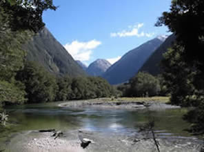
Today’s trail was not only most challenging, but also the most rewarding. We had an early breakfast and started our tramp at 7.30am. The track started to lead toward the head of the Clinton Valley. As we began our climb the 3 leaps of St Quintin Falls could be seen. Soon we started to climb a series of zig zags, and the views on the way up were astounding as the valley floor dropped away beneath our feet.
 |
 |
Once we reached the Mackinnon Memorial, our guides were waiting for us with hot and cold drinks. We stopped here for about 20 minutes to take in the view from the 12 second drop to the Arthur Valley beneath. There were a number of tarns dotted along the way to the pass.
 |
 |
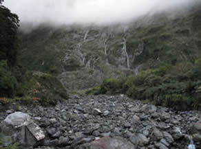
After lunch in Pass Hut the track took us down a long downhill section to Quintin Lodge. On the rocky descend we passed towering rock cliffs, glacial streams, moss covered forest, cascading waterfalls. And soon we had our first view of Sutherland Falls. To me, walking the downhill section of this trail was the hardest.
 |
 |
After a hot cup of tea at Quintin Lodge and leaving our backpacks behind, we went for the 1.5 hour round trip to the mighty Sutherland Falls, fifth highest on the planet at 580 metres. When we were 580m from the base of the falls, we saw a sign indicating that we were now the same distance from the falls as they were tall! The spray of water from the falls increased as we got closer to the roaring base. KC and I did not bring our raincoats but luckily while on our way to the falls we met Marian and Carla, and they were kind enough to lend theirs to us. But the spray was so heavy we had to hide behind a boulder to take some quick shots with our cameras!
 |
Sutherland Falls
Pg 1