nakedeyeview.com.my 2008

The Ascent Of Island Peak - The Climb Of A Lifetime
page 1 of 4
|
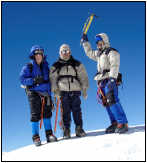
In all our previous mountain trekking expeditions, my fellow trekkers and I had not gone above 6,000m in altitude because above this, we would invariably have to trek on ice, which requires some knowledge and experience on ice climbing. This time, we had chosen Island Peak (6,160m) as our destination. Though my two other fellow trekkers and I have our dream fulfilled, the climb turns out to be our most difficult trekking adventure of our lives. |
A. Introduction
My fellow trekkers and I have embarked on annual mountain trekking expeditions since 2000. The maiden trek was in Mt. Kilimanjaro and last year our annual "pilgrimage" was in northern Mongolia.
In mountain trekking, where one hikes with nothing more than a pair of trekking boots and walking poles, there is a limit to the height one can achieve. To go above 6,000m, one would invariably require some training in ice climbing with crampons, ice axe, ropes etc.
Although there are many more trekable peaks in the Himalayas that are less than 6,000m in height, we seemed to have lost interest in them as we longed to go higher. As age is catching up and before we have to hang up our walking poles, we wanted to experience some ice climbing.
Imja Tse, more popularly known as Island Peak and at a height of over 6,160m, is the most popular climbing peak in Solu Khumbu, the Everest Region. This mountain was named Island Peak due to its striking location in the Chukung Valley, like an island on a sea of ice. The mountain actually extends from the South Ridge of Mt. Lhotse Shar and is separated only by a small col.
It is interesting to note that in the Himalayan Region, mountains are named Mt., Peak or Ri according to their heights. All mountains exceeding 7,000m in height are referred to as Mt., 6,000m to 7,000m as Peak and below 6,000m as Ri.
Four trekkers, Kenny Lim, K C Cheah, Larry Logue and me left for Kathmandu on 22nd of Oct in high spirits, ready to set another personal record in mountain trekking/climbing.
B. The Itinerary
We drew up our itinerary jointly with Abir, our Trekking Agent in Nepal. It allowed us an additional free day in Nepal before returning home just in case we experienced some undue delay in the mountains.
The itinerary we adopted is as follows:
Day 1 (Sat 22/10) - KL to Kathmandu
Day 2 (Sun 23/10) - In Kathmandu, shopping and preparation
Day 3 (Mon 24/10) - Fly to Lukla and trek to Manjo
Day 4 (Tue 25/10) - Trek from Manjo to Namche (3450m)
Day 5 (Wed 26/10) - Rest day in Namche for acclimatizing
Day 6 (Thu 27/10) - Trek from Namche to Tengboche (3860m)
Day 7 (Fri 28/10) - Trek from Tengboche to Dingboche (4190m)
Day 8 (Sat 29/10) - Trek from Dingboche to Chukung (4750m)
Day 9 (Sun 30/10) - Acclimatization in Chukung
Day 10 (Mon 31/10) - Training in Ice climbing
Day 11 (Tue 01/11) - Trek from Chukung to Base Camp (5010m)
Day 12 (Wed 2/11) - Trek from Base Camp to High Camp (5500m)
Day 13 (Thu 3/11) - Climb Island Peak and return to High Camp
Day 14 (Fri 4/11) - Descend from High Camp to Chukung and to Dingboche
Day 15 (Sat 5/11) - Descend from Dingboche to Tengboche
Day 16 (Sun 6/11) - Descend from Tengboche to Namche
Day 17 (Mon 7/11) - Descend from Namche to Lukla
Day 18 (Tue 8/11) - Fly from Lukla to Kathmandu
Day 19 (Wed 9/11) - Rest day in Kathmandu
Day 20 (Wed 10/11) - In Kathmandu - Yak steak, beer garden, shopping & resting
Day 21 (Thu 11/11) - Home sweet home
Note: In the original itinerary, we had allowed an additional day for training in ice climbing. We cut short this training period and ascended the summit a day earlier. But in our return journey, we took an extra day to descend to Lukla because of sheer exhaustion.
C. Trekking from Lukla to Chukung
Trekking route from Lukla to Chukung
C.1 In Kathmandu (22 & 23 Oct)
We flew into Kathmandu on 22nd Oct and Abir, our trekking agent, was on hand to receive us at the airport to deliver us to the hotel in Thamel, the busy tourist district of Kathmandu that we are very familiar with. More tourists were seen this time and shops were doing roaring business.

A busy street in Thamel
We purchased extra warm clothing, which we thought necessary. Also we did not miss our favourite haunts: the beer garden, the Dal Bhat restaurant and the Everest Steak house.
Our Sherpa guide, Pasang, came to our hotel to check on the boots and clothing we had for the trip. However, we did not discuss with him about the conditions of the tracks along the route and the temperatures we were expected to encounter. Earlier, we were led to believe that the conditions would be similar to those in Annapurna Circuit, which we trekked in 2001.
C.2 Trekking from Lukla (2,788m) to Namche Bazaar (3,345m) (23 & 24 Oct)
We left our hotel in Kathmandu before 6.00am in the morning and without breakfast in order to catch the first flight out to Lukla where our trek would begin. It was important that we left early because the later flights would always be delayed because of fog, which often prevailed later in the morning.
We boarded the small 16-seater propeller plane before 6.30am and half an hour later we approached Lukla. From the air, Lukla airport seems to be sited along a sloping ridge with an inclined paved runway, which suddenly terminates into a small parking apron lying just next to a massive vertical mountain face!
After our breakfast in North Face Resort, a stone's throw from the tiny airport, we commenced trekking just before 9.00am. Three young porters were hired to carry our luggage and other necessities. Besides Pasang, a young assistant Rabin, who is one of Abir's nephews and a first timer on the trek, accompanied us.
The first day of our trek was easy, it was downhill all the way to Phakding. The trail traversed the side of Dhote Koshi River and we reached Phakding just before noon. After our lunch in Phakding we decided to move on. In two more hours of trekking, we reached Manjo (2,777m) and decided to put up here for the night.
The next day (24th Oct) we resumed our journey after 9.00am. We spent the first hour of our trek following Dhote Koshi River and crossed it three times. However during the next two hours of trekking we ascended all the way to Namche Bazaar (3,345m). Here we stayed in Khumbu Lodge for the next two nights.

Namche Bazaar
Though the Khumbu Lodge was reasonably clean and comfortable, it was clearly designed to impel guests to pay extra for basic services like having a hot shower and charging of batteries. These facilities were installed in rooms but they were disconnected from the main electric supply. We had to pay 200Rs for a hot shower, 300Rs per hour for battery charging and 100Rs for a liter of hot water.
Internet service, though available in the Lodge, was expensive at 15Rs per minute. In some Internet cafés in town, it was 10Rs per minute. We later found out that this was the last place where Internet services were available.
Namche Bazaar is a thriving tourist town full of lodges and shops. It is a gateway to many trekking/climbing destinations in Solu Khumbu. From here one can go to Gokyo in the northwest, to Kala Pattar and Everest Base Camp in the north and to Ama Dablam, Chukung and Island Peak in the northeast.

A busy street in Namche
Because of its strategic location, the trails leading to and away from Namche are often jammed with trekkers, porters and jobukes, a yak and cow mix. The traffic norm along the trail is to allow the jobukes the right of way, followed by the porters.

Crossing a bridge

"Traffic" jam!

Jobukes have the right of way
Note:
1. A yak is a male. A female is called Nak.
2. A cross between a yak and a cow is known as "zhom" for a female and "jobuke" a male.